
Storm Upgraded To Tropical Depression
Aug. 26 Evening Update | The invest in the tropics that we have been monitoring has just upgraded to a Tropical Depression by the National Hurricane Center. While Charlotte County isn’t in the 3-day or extended cone right now, remember that impacts can stretch beyond it. The cone focuses on the storm’s center path. Mainly heavy rainfall is expected in Charlotte County, but don’t disregard other risks. Much of the severe weather will likely be east of the storm’s center.
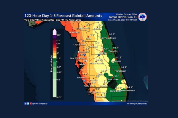
???? There’s a marginal risk of excessive rainfall for west central and southwest Florida. Coastal spots might see up to 6 inches, with around 4 inches widespread. Be prepared for potential localized heavier amounts. Watch out for high tide increasing the possibility of street flooding near the coast.
???? Predicted storm surge remains at 3 to 5 feet. The storm’s trajectory will determine the areas at highest risk of surge.
???? Possibility of Tropical Storm force winds on Tuesday and Wednesday. In Charlotte County, there’s a 25% chance of experiencing these winds (39mph) and a 4% chance of stronger Tropical Storm force winds (58mph). Percentages may change as the forecast updates.
Please continue to make sure that you and your family are prepared for what might come of this tropical depression or whatever we may face the rest of hurricane season.