
Tropical Storm Warnings Posted As Idalia Gains Strength
The 5:00 p.m. intermediate advisory from the National Hurricane Center has been released.
The sustained winds have reached a maximum of 40 MPH. Its current movement is towards the north at a speed of 3 MPH.
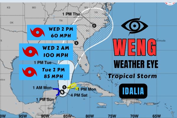
While the storm is anticipated to make landfall in the Big Bend/Panhandle area, meteorologists from The Weather Authority have stated that Southwest Florida should expect rainfall, winds, and some beach erosion on Tuesday and Wednesday.
The NHC has also mentioned the possibility of issuing storm surge and wind watches for parts of the Florida west coast on Sunday.
At this moment, Tropical Storm Idalia is causing heavy rainfall in parts of western Cuba and the Yucatan Peninsula. As it heads towards Florida, it is projected to strengthen into a hurricane by Tuesday over the waters of the eastern Gulf of Mexico.
Watches and Warnings
A Tropical Storm Warning is in effect for:
- Yucatan Peninsula from Tulum to Rio Lagartos, including Cozumel
- Pinar del Rio Cuba
A Tropical Storm Watch is in effect for:
- Isle of Youth Cuba
- South of Englewood to Chokoloskee, Florida
- Dry Tortugas, Florida